Walk 7: Hazlehead and Den of Maidencraig Circular Walk

Summary
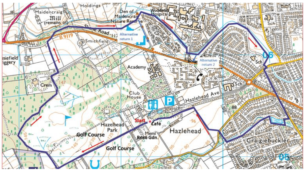
A five-mile circular walk starting from the café at Hazlehead Park, along the Denburn and returning via the Walker Dam. There is plenty of parking at several car parks along Hazlehead Avenue. Two alternative return routes which reduce the length of the walk are included in the description. Hazlehead café is near the car parks.
Walk Details
- Grade: Moderate.
- Terrain: Mostly along tracks and footpaths but a
short road section and one part along the Denburn
is across a grassy area which can be muddy.
Boots recommended. - Distance: 5.0 miles. 8 km.
- Time: Allow 2.5 hours.
- Waymarked: No.
- GPX: Yes.
Directions
Hazlehead to Den of Maidencraig
Start at the front of the café and head west along a path past the Queen Mother rose garden until you arrive at the exit, cross the road and head along track with the golf course on both sides. At the far end there is a T junction road, turn right and shortly reach a triangular junction. Bear left with rough ground on your left and golf course on your right. At the start of a forested area where the path splits take the path to the right (signposted ‘Skene Road’). Follow the path till about hundred yards after the golf course on your right finishes and you see both the Crematorium on your left and an open area marked with boulders. Turn left across this open area to the road leading to the crematorium.
Turn right and within a few yards, at the gates to the crematorium, there is a path (signposted ‘Maidencraig’) to the left with open fields on either side. Along this path there is a distant glimpse of the sea and King’s College crown tower. When the ‘access only’ road is reached turn right and cross, very carefully, the busy Skene Road to the path opposite.
There is a ‘Den of Maidencraig’ sign and an information board. The path is quite rocky and tricky in places, including a wooden bridge, slippery when wet, so take care, but the path soon leaves Maidencraig wood and enters more open countryside, Den of Maidencraig. (An alternative avoiding the tricky section is to walk along the road for 100 yards and take another entrance on the left.)
The Denburn is on your left and the Woodend Hospital water tower ahead. This a nature reserve so keep a lookout for animals and birds and a pond is soon reached. If you are lucky the local Mandarin duck may be here (or at the Walker Dam).
Den of Maidencraig to Hazlehead
Just past the pond is the first alternative route back to the start, signposted ‘Hazlehead Academy’. Don’t go over the burn but continue on the south side. The tarmac finishes after a few yards and the walk continues along a grassy area. At the end find, by following the fence line on the left, a narrow entrance to a path which passes under the road bridge to Woodend Hospital, but avoid the path which crosses over to the north side of the burn. The path then meets a better path. If you want to take the second alternative way back to the start, turn sharp right at this point; otherwise carry on keeping the Den Burn on your left until you reach Kings Gate, at the Fernielea Road junction. Cross over, turn right and then left into Springfield Road.
At the traffic lights at the junction with Queen’s Road continue along Springfield Road to Woodburn Gardens. Turn right and immediately left down a grassy bank to the Walker Dam. If the grass is too slippery you can continue further along Springfield Road and take path signposted ‘Hazlehead Park’. After traversing the dam turn right and follow the path along the burn, over Craigiebuckler Avenue (keeping to the left side of the burn), and continue to the end where you turn right, over the burn and within a few yards meet Hazledene Road. Cross the road and cut across a grassy area till you meet a rough track from Hazledene Road to Hazlehead Avenue, carparks and café.
